Soils of Homoxi
The soil observations and samples listed in Table 7 were made at selected sites whose locations are indicated in Figs 58 and 59. Data on soil profiles and chemical analyses are provided in Appendices 5 and 6.
Natural soil types
Red-yellow dystrophic latosols (medium texture) dominate the upper slopes and tops of the hills in the Homoxi region. They present deep profiles (greater than 1.5m) and are probably based on basic intrusive rocks from the Complexo Guianense. They are old, acidic to strongly acidic, and well drained. The profiles show the following sequence of horizons: A, AB, BA and B. Colours range from brown (7.5YR 3/3, 5/8) to red-yellow (5YR 5/8) with little differentiation between the A and B horizons. The sand fraction makes up over 60% of the granulometric composition. The textural relationship B/A of 1.8 shows characteristics of argisols.
The red-yellow latosols at Homoxi are of low to medium natural fertility and dystrophic (base saturation <50% across the profile). CEC (Cation Exchange Capacity) is highest towards the surface on account of the presence of organic matter there. According to Schaeffer (1996) these types of soils are developed from reworked material, normally resulting in chemically poor soils. These characteristics are reinforced by the climatic conditions in which they have developed, which intensify the processes of leaching.
Yellow dystrophic latosols (medium texture) are found on the lower slopes of the hills at Homoxi and in the valleys (where they had not been removed by garimpeiros). They are generally deep and are probably overlying granites and gneisses of the Complexo Guianense and sandstones of the Paleolithic formations. These soils are old, acidic and well drained, and in some cases are substantially clayey. Profiles show A, AB, BA and B horizons and the colour is predominantly brown (10YR 4/2 and 10YR 6/8) both in the A and B horizons, although the latter may be yellowish (10YR 7/8). In general there is little differentiation between the horizons.
Like the red-yellow latosols, these soils are dominated by their sand fractions and show low natural fertility. They are dystrophic and the highest CTC values are found at the surface. Again, the textural relationship between the B and A horizons suggests an argisol.
Hydromorphic sandy soils are found in the baixadas (damp depressions and streamside areas) in the forest. However, in most of these areas the soils have been disturbed by garimpeiros.
Soils and gravels on areas disturbed by mining
How the soils were altered
The garimpeiros generally started at the
edge of the river and gradually worked their way away from it. The forest was cut down in the area to be
mined and the topsoil was removed with high-pressure water hoses. The liquefied soil was washed into the hole
left by the previous workings. The
gravels were then worked for their gold, and transported to the same hole. When the layer of greenish or bluish clay
underlying the gravels was reached, the equipment was moved on and a new site
was begun (passing the waste materials into the new hole). Thus, as the garimpeiros moved away from the river, they left a swathe of gravel
behind them. The topsoil that had
originally covered it was now either underneath the gravel (effectively an
inversion of the original profile) or else washed downstream.
The most significant anthropogenic substrates in the Homoxi region are the (predominantly quartzite) gravels. These are most obvious in the raised banks and mounds that have been formed along the course of the Mucajaí and some of its tributaries. There is considerable variation in these gravels and in the quantities of sand present among them, but in general the finer fractions are most abundant in the areas of lowest topography. In some of these places sand and silt have accumulated on top of the gravels to form a distinct layer. This may contain some organic matter resulting from decomposing vegetation, which is generally more abundant and exuberant (shrubs and occasionally trees) in the depressions than on the higher gravels (which mainly support a sparse cover of grasses and lichen).
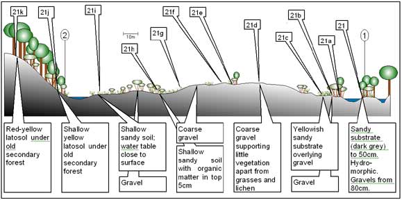
Figure 1: Profile across gravels
beside the Rio Mucajaí
The finer organic material in the depressions was almost certainly washed out of the gravels above it by the rain. In some areas, however, these materials have probably been deposited by flooding of the river. There is substantial chemical variation in these substrates, but in general they are poor in disposable nutrients.
Table 1: Soil samples/observations taken at Homoxi
|
Sample |
Substrate |
Brief description |
|
1 |
Gravel |
Bottom of a baixada in the forest. Site of small
mine working. Some secondary species
(e.g. Cecropia sciadophylla)
present in the canopy. Sandy
substrate with gravel. Some shrubby
regeneration. |
|
2 |
Soil |
Yellow latosol in dense terra firme forest towards the bottom
of a hill. |
|
3 |
Gravel
and sand |
Open mining site
(relatively flat) covered in herbaceous vegetation (many Pityrogramma calomelanos ferns) with some shrubs. Sandy substrate. This site has probably been mined manually. |
|
4 |
Gravel
and sand |
Small open area at edge of
secondary forest, probably seasonally flooded by nearby stream. Possibly former course of diverted
stream. Shrubby vegetation. Top 5cm
with organic material. Grey sand from
5-20cm. |
|
5 |
Gravel |
Dry raised area at edge of
secondary forest with large quantities of Inga
edulis, to a height of about 15m.
Dense leaf litter and root system present on surface. |
|
6 |
Soil |
Red-yellow latosol on the
top of a hill. Dense terra firme forest. |
|
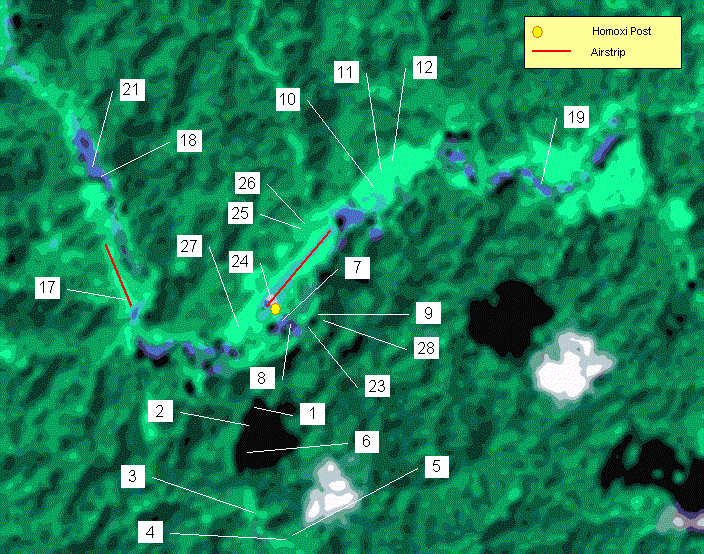
7 |
Gravel |
Area of gravels with small
patches of shrubby regeneration to a height of 2.5-3m (with small
accumulations of leaf litter) in the depressions. |
|
8 |
Gravels |
Alternating hillocks of gravels
with depressions with finer substrate.
The hillocks are colonised by grasses and occasional small
bushes. Shrubby regeneration to
2.5-5m on the finer (sandy) substrates in the depressions. |
|
9 |
Sand |
Hydromorphic substrate with
water table 60cm below ground level.
Alternating sand and fine gravel under secondary forest. |
|
10 |
Soil |
Yellow latosol in an
abandoned garden (with some old banana trees) dominated by the tall grass Setaria sulcata. |
|
11 |
Soil |
Yellow latosol under
secondary forest to 15m dominated by Cecropia
sciadophylla. Abandoned Yanomami
garden. |
|
12 |
Soil |
Yellow latosol under a
dense cover of Pteridium arachnoideum
in an area that was accidentally burned by the Yanomami. |
|
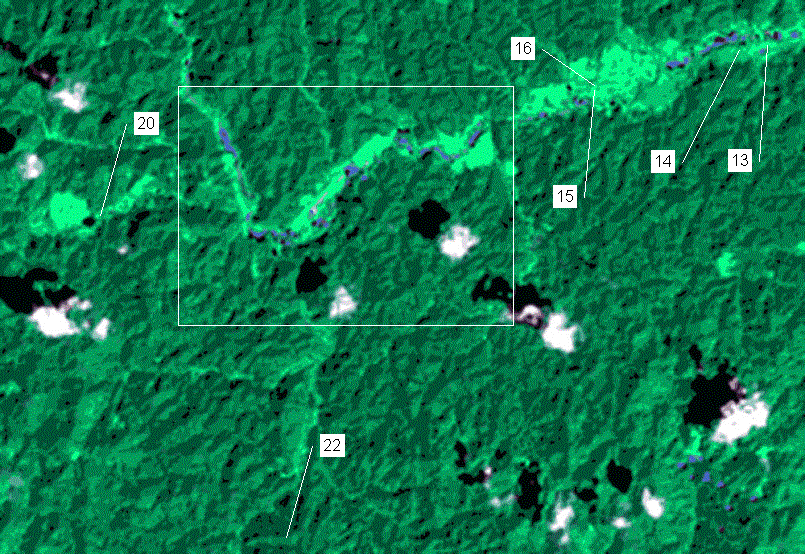
13 |
Soil |
Yellow latosol on the
Baiano Formiga airstrip under a dense cover of tall Paspalum grass and other herbs. |
|
13a |
Soil |
Yellow latosol under secondary forest dominated by Vismia guianensis at the edge of the Baiano Formiga airstrip. The soil is more clayey than the sample from the strip itself (13). |
|
14 |
Soil |
Yellow latosol in abandoned Yanomami garden (at least 15 years old) dominated by Cecropia sciadophylla trees to 30-35m to 50cm dbh. |
|
15 |
Gravels |
Secondary vegetation dominated by dense, slender-stemmed Vismia guianensis on gravel substrate near the end of the Macarrão airstrip. |
|
16 |
Soil |
Sandy yellow latosol on the Macarrão airstrip under a dense cover of tall Paspalum grass and other herbs. |
|
16a |
Soil |
Sandy yellow latosol under secondary forest dominated by Vismia guianensis at the edge of the Macarrão airstrip. |
|
17 |
Soil |
Sandy yellow latosol on the Chimarrão airstrip under a dense cover of tall Paspalum grass and other herbs. |
|
17a |
Soil |
Sandy yellow latosol under secondary forest dominated by Vismia guianensis at the edge of the Chimarrão airstrip. |
|
17aa |
Soil |
Crater formed by explosion on Chimarrão airstrip, surrounded by shrubs on loosened earth. Sandy yellow latosol. |
|
18 |
Gravels |
Coarse gravels underlain by friable sandy substrate mixed with gravel. Gravels supporting sparse grassy vegetation, with small islands of shrub regeneration in lower areas. |
|
19-19b. Profile across gravels (Fig. 52). Coarse gravels alternating with patches of
white or yellow sand [evidence of oxidisation; the samples were collected
after a night of rain. |
||
|
19 |
Gravels |
Gravel bank approximately 1m high. Top covered by grassy vegetation; slopes with grasses and shrubs. Material damp to 40cm. |
|
19a |
Gravel and sand |
Flat surface; substrate slightly damp. White sand mixed with yellow (hydromorphic) sand. Vegetation cover of grasses, ferns and lichens. |
|
19b |
Gravel and sand |
Flat surface with friable sandy substrate. |
|
20 |
Soil |
Yelow latosol at edge of abandoned Julio de Blefe airstrip. Secondary forest. |
|
21-21k. Profile across gravels upstream of Pista
Chimarrão (see Fig. 53). |
||
|
21 |
Gravel and sand |
Small island in river. Sand dark grey to approx. 50cm; below that bluish-grey (apparently hydromorphic). Secondary vegetation 5-10m. |
|
21a |
Gravel and sand |
Right bank of the river; soils and vegetation similar to 21. |
|
21b |
Gravels |
Upper part of river bank with friable sand/gravel mixture. Below 40cm gravels too coarse to be sampled with augur. Secondary shrubby vegetation. |
|
21c |
Gravel and sand |
Flat area with coarse gravels and some sand, varying from white to yellow. Herbaceous vegetation with occasional shrubs. |
|
21d |
Gravels |
Elevated area of coarse gravels with grasses and lichens. |
|
21e |
Gravels |
Depression in gravels with some finer material and island of shrubby regeneration, situated at base of a gravel pile 1m high. |
|
21f |
Gravels |
Elevated area of coarse gravels with grasses and lichens. |
|
21g |
Gravels |
Gravel slope; finer material more abundant towards bottom. Sparse grassy vegetation with shrubs becoming denser towards bottom. |
|
21h |
Gravel and sand |
Damp low area with sandy substrate; presence of organic material in the top 5cm. Shrubby regeneration dominated by Piper aduncum. |
|
21i |
Sand |
Sandy substrate close to lake, becoming hydromorphic. Herbaceous vegetation with Pityrogramma ferns and Lycopodium cernuum. |
|
21j |
Soil |
Shallow yellow latosol on slope clothed in secondary forest to 15-20m. |
|
21k |
Soil |
Deep red-yellow latosol towards top of small hill with secondary forest. |
|
22 |
Soil |
Red-yellow latosol
beneath dense terra firme forest on
top of a ridge SW of Homoxi on the trail to W |
|
22a |
Soil |
Red-yellow latosol
beneath dense terra firme forest half-way up a ridge SW of Homoxi on the
trail to W |
|
22b |
Soil |
Yellow latossol near
the bottom of a ridge SW of Homoxi on the trail to W |
|
23 |
Sand |
Hydromorphic grey sandy substrate in a baixada close to a stream in an area apparently not disturbed by gold mining. |
|
24 |
Soil |
Recently burned Yanomami garden. |
|
25 |
Soil |
Soil under secondary forest on slope of ridge alongside the Homoxi airstrip; possibly a transition to yellow latosol from red-yellow latosol. |
|
26 |
Soil |
Red-yellow latosol under terra firme forest on top of the ridge alongside the Homoxi airstrip. |
|
27 |
Soil |
Yanomami garden behind the Tirei maloca; the top 15cm is black and hard, passing to yellow (latosol) at greater depth. Low productivity of bananas in this garden but high manioc productivity. |
|
28 |
Soil |
Yanomami banana plantation on slope SE of the Post. Dense cover of herbaceous material with ferns. |