Spatial use of resources at Homoxi
Tirei
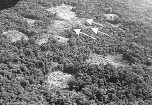
The best soils in the vicinity of the Post were said by the Yanomami to be those along the rivers (dark, fertile and good for growing manioc), followed by those on the lower slopes of the hills bordering the Mucajaí valley (orange, compact, less fertile but suitable for sugar cane and bananas). Although much of the most fertile soil has been destroyed by mining activities, the Tirei reckon that there is still a reasonable amount of cultivatable land in the area, principally on the left bank of the river close to and downstream of the Post. However, the four gardens at Tirei currently in production appear to be relatively small in area for 85 people.
Game, in spite of having been overexploited and scared away by the garimpeiros, appears to have undergone some recuperation in the region.[1] However, the hunting activities of the Tirei appear to be less intense than would normally be the case in a Yanomami community, and the group spends large amounts of time visiting other areas.
These facts indicate that, in addition to the indisputable environmental factors presented elsewhere in this report, the disruption of the socio-economic equilibrium of the group during the gold rush still exerts a negative influence on the subsistence activities of the Tirei. Various factors have likewise influenced their production systems, such as the loss of older leaders to organise collective activities, the dependency on food supplies from the garimpos and support organisations over the last ten years, and the chronic incapacitation caused by the malaria epidemics during the 1990s. It should be remembered that the last garimpeiros only left the Homoxi region in 1998 (eight years after the operation to remove them was launched), and that malaria only began to diminish significantly in the area in 1999-200 when URIHI took over the health support. In addition, a period of incursions and counter-incursions with warriors from the Kuremau theripë from the Mamopë u river (a tributary of the Mucajaí downstream of the Pau Grosso airstrip), and the mobilization of a work force to build the URIHI health between 20000 and 2001, certainly would not have helped to rectify the problems caused by the garimpo.
It should be noted that the hunting and collecting activities are primarily focused on the area upstream of the Post, while downstream (as far as the Apiahipi u) only crab and prawn collection, fishing (with fish-poison) and paca hunting are practised. Some game (curassow, guans, armadillos, pacas, spider monkeys, howler monkeys etc.) has returned to the upper reaches of some of the tributaries downstream of the Post such as the Hayaakoari u, Kunaathepi u and Oruxipi u, particularly in areas described by the Yanomami as ‘patches of beautiful/healthy forest (urihi totihi/temi patiopëha). The upper course of these rivers is also rich in momohi trees, whose fruits are very abundant and highly appreciated by the upland Yanomami for ceremonial food at multi-community festivities (reahu). Caterpillars (specifically kaxapë), which are also collected in large quantities during the season, are also abundant up these rivers.
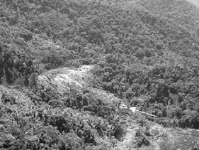
The forest downstream of the Post, apart from the Apiahipi u, is less frequented partly on account of the detritus (glass, tins, motors, pipes etc.) that litter it. This is known by the Yanomami as urihi wariopëha (where the forest has been destroyed).
Xereu
The soils of the Xereu area were said to be greyish-orange and very sandy with a very thin humus layer. They are considered by the Yanomami to be of medium fertility, and macaxeira (sweet manioc) never develops well in them. At the sites previously occupied by the group further down the Xere u the soils were said to be more fertile, having a deep black layer. These soils were excellent for development of macaxeira. However, suitable sites were very sparse.
The gardens of the northern community at Xere u are located on the slopes of the nearby hills, and water is taken from a small stream close to the houses. The three large gardens of the southern community are reached by a small forest trail, and are also situated on (very steep) hill slopes. Water is taken from the Xere u which is reached by means of another path: a considerably less convenient arrangement than at the other site.
Fishing at Xereu is mainly done with fish poison in the lower reaches of the river (above the Pixatahuripë u and Opoxihi uprai u streams). The fish are always small (maximum 10-15cm). Crabs and shrimps are taken along the same stretch of river.
There are several daily hunting trails on
the right bank of the Xere u, where
pacas, collared peccaries, armadillos, curassow etc. can be found in reasonable
abundance. On the left bank of the
river there are trails to the surrounding hills where spider monkeys can be
found, as well as a trail for collective hunting/ gathering trips to the upper Hokotomana u (tributary of the upper
Mucajaí where deer, collared peccary, curassow, armadillo and xoko can be hunted). Additional collection trails leave this
route for the collection of important fruits such as momo kiki and kaxapë
caterpillars.
Finally there is a network of long-distance hunting/gathering trails in the direction of the Topara u and Koroxo u rivers (also tributaries of the Mucajaí) where larger species such as tapir, giant armadillo and anteaters are hunted, as well as more common game such as curassow, trumpeters, collared peccaries etc. and spider monkeys (in the hills in the headwaters of the Topara u).
|
|
|
|
Figure 1: Yar |
|
Yaritha
The soils of Yaritha are considered to be very fertile and are
described by the Yanomami as blackish-grey, slightly sandy/granular, soft, and
rich in worms. They are regarded as
incomparably better than those at Wiramapiu. The houses of the Yaritha theripë are surrounded by vast
gardens in different stages of production.
There are a number of medium-sized rivers in the area that guarantee
abundent access to water, even during the dry season (September to March).
There are large numbers of old peach palm plantations in the region, which was occupied in the remote past by the same (non-Yanomami) tribes that lived in the Toototobi region (tributary of the Rio Demini) in Amazonas. These old gardens are called Wanapi u (a small tributary on the left bank of the Orinoco below the Ruapë u) and Ixinapi (upper Ruapë u).
At Yaritha
there are various paths leading to clusters of bacaba palms (Oenocarpus bacaba), and one leading to a
patch of apiahi (Micropholis melinoniana) trees.
In addition to abundance of fruit trees there is also no lack of game in
the region. The Yanomami claimed that
“this forest doesn’t have the property of hunger!” (hwei thë urihi në ohiimi). They also claim that the area has acted as a refuge for the
wildlife that was displaced or over-hunted by gold mining operations in the
Mucajaí valley (“That’s where the tapir, spider monkeys and curassow fled to”).
The men at Yaritha hunt daily along
various rivers, in particular the Uxupi u
and the Mahanasipi u (tributaries of
the Hayathë u), but also
on the Wiramapi u. Pacas are
also often hunted by night on these rivers and along the Hayathë u. These
rivers, as well as the Ruapë u, are
also rich in small fishes, crustaceans (prawns and crabs) and shellfish (xitokoma akasipë). Tadpoles (xããxipë) and frogs are also collected there. There are plenty of caiman (Caiman crocodilus), which have
practically disappeared from the Mucajaí on account the garimpo. Long term
(long-distance) coillective hunting trips are mainly made to the west of the Hayathë u, along the Wanapi u (tributary of the Orinoco) and,
crossing the Orinoco, to the basins of the small tributaries (igarapés) of its right bank.
Both the Tirei theripë
and the Xereu theripë have
‘support gardens’ in the Yaritha
region. These are said not to have been
established in preparation for future moves to the area, but as supplementary
sources of food. They have established
temporary camps of ‘tapiri’ shelters (naa
nahipë) beside these gardens, from which they take bananas, sweet manioc,
yams and sweet potatoes to carry with them on their collective hunting trips to
the upper course of the Kripisipi
u and the Wanapi u (on the left
bank of the upper Orinoco). The hills
there are rich in tapir and monkeys, and when they feel the lack of meat in the
region of the Homoxi Post in the ‘time of the fat monkeys’ (paxo kiki witeo tëhë) they
make long trips to these areas.
The Tirei
theripë have three gardens
on the Ukuxipi u and one on the Eheremaxipi u (tributary of the Mahanasipi u). One of the reasons for establishing subsidiary gardens and
long-term hunting trails in the Yaritha
region must be their recent conflicts with the Kuremau theripë (1995-1999), which rendered the region
to the north of the Homoxi Post insecure and necessitated the establishment of
a potential retreat away from the Post and close to allied groups.