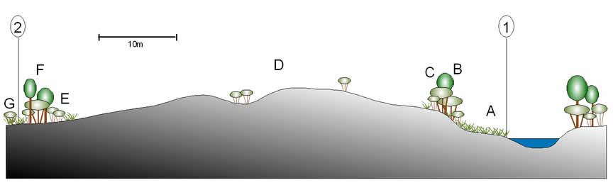
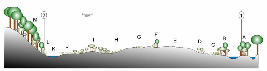
The vegetation of Homoxi

The vegetation in the Homoxi region is a mosaic of undisturbed and disturbed habitats including terra firme forest, streamside and riverside forests and herbaceous tangles, open areas of gravel and sand with sparse herbaceous or scrub cover, and secondary forests on variable soils resulting either from garimpeiro activity or from Yanomami cultivation.  The terra firme forest is by far the dominant vegetation type covering this undulating landscape, and secondary vegetation is almost entirely limited to the bottoms and sides of river valleys.


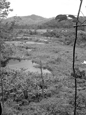
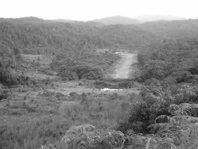
Figure 1: Views towards the Homoxi Post from the South (left) and from the East (above)

The vegetation descriptions that follow are intended as brief characterisations of the main categories that were identified.  More detailed lists of the species recorded in each environment can be found in Appendix 2.

Natural environments

Forest

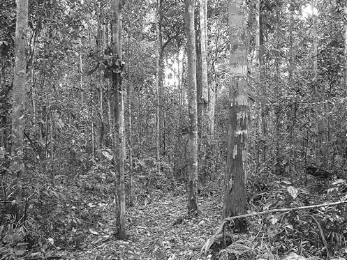
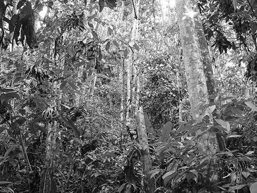
The forest in the Homoxi region is reasonably homogeneous, with a canopy approximately 25-30m high and emergent trees to 40m+.  There are relatively few trees over 40cm in diameter, lianas are common, and the understorey is fairly open.  In the higher areas (around 1000m) the forest appears to be slightly more open with a lower canopy and fewer large trees, but this has not been quantified. A dense root mat covers the soil surface on the hillsides.  Given the undulating nature of the terrain there are also inevitably some differences between the structure and composition of the forest from one area to another, on account of topographic and hydrological variations.


Figure 2: Large individual of Cedrelinga catenaeformis in the forest near Homoxi

Figure 3: Forest on hill top at around 1000m altitude SW of the Homoxi Post

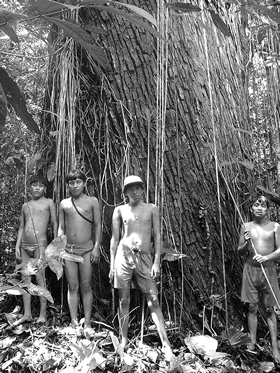
Among the common and conspicuous canopy tree species are Clathrotropis macrocarpa, Micrandra rossiana, Alexa confusa, Swartzia schomburgkii, Chimarrhis sp., Caryocar pallidum, Dacryodes roraimensis, Ormosia steyermarkii, Eschweilera spp., Pourouma spp., Protium fimbriatum and Pseudolmedia spp.  Smaller tree species such as Anaxagorea dolichocarpa, Amphirrhox surinamensis, Duguetia lepidota, D. stelechantha, Mouriri guianensis, Myrcia spp. and Trymatococcus amazonicus are common elements of the understorey.  One of the more common emergent trees is the leguminous Cedrelinga catenaeformis, a particularly large individual of which was encountered with a diameter of over 3m.

There are very few large palms in the terra firme forest apart from the occasional individual of Oenocarpus bacaba or (more commonly) Socratea exorrhiza.  In the lower understorey, however, they are more abundant, with Iriartella setigera and Geonoma spp relatively common and occasional individuals of Astrocaryum gynacanthum, Bactris corosilla and Hyospathe elegans.

Lianas are relatively abundant in the forest, conspicuous species including Bauhinia guianensis, Pinzona coriacea and Abuta rufescens.  The ground layer includes the omnipresent Psychotria poeppigiana, various species of Piper (with P. francovilleanum particularly common), Tabernaemontana macrocalyx, Urera baccifera, a common Anthurium, Heliconia spp. and some Marantaceae (including Ischnosiphon arouma). 

Mosses and lichens are abundant on the trunks and branches of the trees, as are a range of vascular epiphytes including Orchidaceae (e.g. Maxillaria spp.), Araceae (including Anthurium clavigerum, Philodendron hylaeae, Heteropsis steyermarkii, Cyclanthaceae (Asplundia sp.), Piperaceae (Peperomia rotundifolia), Gesneriaceae (Codonanthe sp.) and various Pteridophytes.

Figure 4: Apparently undamaged stretch of the upper Mucajaí showing riverine forest with herbaceous vegetation on the bends

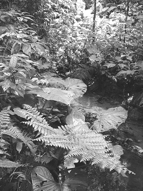
Baixadas and forest streams

Baixadas are depressions in the forest, sometimes containing streams, where the soils are damper than on the surrounding slopes.  In lowland regions of the Yanomami area these are often dominated by palm species such as Mauritia flexuosa, Socratea exorrhiza or Jessenia bataua.  In the Homoxi region this does not appear to be the case, and most of the baixadas and stream-beds have been substantially disturbed by gold mining.  Nevertheless it was possible to observe the vegetation of one apparently undisturbed baixada on the far side of the river from the Homoxi health post.

Although there were a few trees to 30cm diameter and 20 m in height, most of those in the base of the baixada were relatively small (few exceeding 10cm diameter and 10m height). Common trees included Inga spp., Elizabetha princeps, Aparisthmium cordatum and Chrysochlamys membranacea with the occasional stilt-rooted Socratea exorrhiza palm.  The shrub and herbaceous layer was denser than in the forest on dry ground on the hills, including Xanthosoma sp., various ferns (incl. Salpichlaena volubilis and Metaxya rostrata), Piper spp. (incl. P. dilatatum and P. glabrescens), Miconia serrulata, M. nervosa, Loreya spruceana, Machaerium sp., Aphelandra macrostachya, Heliconia bihai, Costus sp., Olyra longifolia, Besleria sp., Urera baccifera and Renealmia alpinia.  Araceous epiphytes/ climbers (i.e. Philodendron spp.) were abundant, and there were a number of vines present including Drymonia coccinea and Asplundia sp.


Figure 5: Vegetation in an undamaged baixada

Figure 6: Forest igarapé


Botanical similarity to Xitei

The forest at Homoxi was found to be similar in terms of both composition and structure to that of Xitei, which lies at a similar altitude (620m) and was visited briefly by WM in 1995.  Given its relative proximity it is very likely that the species collected at Xitei during that visit would also be found in the Homoxi region.  A list of additional species is given in Appendix 4.

Altered environments

Gravels

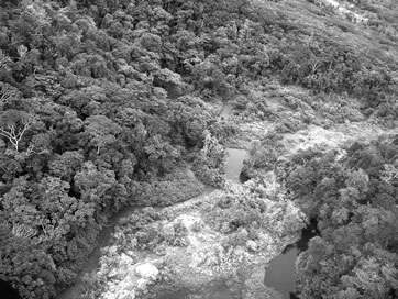
The most severely altered environments in the Homoxi region are the raised areas of quartzite gravels alongside the Rio Mucajaí and its tributaries.  These areas have virtually no topsoil and are generally covered in very sparse vegetation composed mainly of grasses such as Axonopus purpusii, Digitaria sp. and Andropogon angustatus, often in association with a common lichen (Cladonia subradiata).[1]  There are usually occasional scattered herbs such as Emilia sonchifolia and Chamaecrista nictitans. 

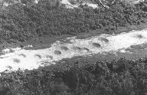
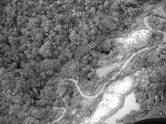
Amongst the gravel mounds are scattered small depressions where shallow deposits of sandy soil have accumulated – presumably washed out of the surrounding gravels by rain.  These depressions support denser concentrations of herbaceous species such as Elephantopus mollis (a very common herb in secondary vagatation of all kinds at Homoxi) and occasional shrubs and small trees such as Psidium guajava, Mahurea exstipulata and Clibadium cf sylvestre.  Other shrubs/trees occasionally found on the gravels include Clusia grandiflora, Cecropia cf latiloba, Ficus sp., Coussapoa asperifolia There is a considerable amount of insect activity on these gravel areas: many are crossed by a network of leafcutter ant trails, which are clearly visible from the air as white lines. 

Apart from the grasses, the most important familiy of herbaceous plants in the gravel areas are the Compositae.  These include Acanthospermum australe, Ageratum conyzoides, Bidens bipinnatum, Conyza bonariensis, Elephantopus mollis, Emilia sonchifolia, Eupatorium odoratum, Piptocarpha triflora and a number of other species.  Other common herbs include Scoparia dulcis (Scropulariaceae) and isolated concentrations of terrestrial orchids such as Epidendrum ibaguense and Sobralia sessilis.  Burned patches are sometimes dominated by Pteridium arachnoideum fern (see below), and another terrestrial fern (Nephrolepis sp.) was found to be common in isolated areas.

Figure 7: Aerial view of regenerating mining areas at Homoxi, showing the white areas of sparsely vegetated gravels

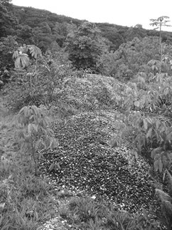
Although the main gravel areas do have some sand interspersed with the quartzite, in some places there are conical piles of pure quartzite gravel that appear not to have changed at all since they were deposited by the garimpeiros.  Most of these cones, which are rarely more than 3-4m across, support no plants at all (except for the occasional Pityrogramma fern).

Towards the edges of the gravel areas there are usually patches with shallow sandy soil in which there has been regeneration of shrubs, woody vines or herbaceous tangles.  These vary considerably from one place to another.  In some areas, for example, there is little apart from a dense thicket of Piper aduncum to a height of 3-4m.  In others there is an almost impenetrable vine thicket dominated by the spiny Uncaria tomentosa, or else patches of Baccharia triplinervis and Lantana trifolia.  Oreopanax capitatum (Araliaceae) was found growing in one such area, as were patches of the alien grass species Melinis minutifolia (capim gordura).  A common component of these thickets is the attractive leguminous vine Dioclea reflexa, which sprawls over the shrubs (or sometimes herbs) in a dense blanket.


Figure 8: Typical mined area at Homoxi

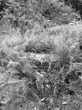
Areas of wetter ground often support large quantities of the fern Pityrogramma calomelanos and, in places, Lycopodium cernuum or Paspalum cf amazonicum.  Cyperaceae such as Cyperus luzulae, C. surinamensis, Scleria cf microcarpa and Kyllinga pumila are also common in these damper areas.


Figure 9: Gravel area to the W of the Post

Figure 10: Piles of quartzite gravel


Figure 11: Edge of a lagoon in gravel area with dead trees behind

Figure 12: Camp area of gravels with abundant Pityrogramma ferns

The forest edge and secondary forests

The composition of the forest edge at Homoxi is variable but includes a typical selection of secondary forest shrubs and trees such as Lantana trifolia, Jacaranda copaia, Laetia procera, Croton palanostigma, Vismia spp., Senna sylvestris, Bellucia grossularioides, Aparisthmium cordatum, Clidemia hirta, Machaerium spp., Leandra sanguinea, Miconia spp., Piper spp., Schefflera morototoni and Solanum spp. (S. rugosum, S. dumosum, S. crinitum and S. stramoniifolium).  Palicourea guianensis, with its bright yellow inflorescences, was a particularly conspicuous species in this habitat, as was the common tree fern Cyathea delgadii vel aff.  Common vines included Mucuna pruriens, Stigmaphyllon sinuatum, Dioclea reflexa, Cissus spp., Passiflora coccinea, Momordica charantia, Securidaca sp., Mendoncia aspera and Mikania micrantha.  Species such as Elephantopus mollis, Desmodium spp., Heliconia spp. (incl. H. psittacorum), Pothomorphe peltata, Costus spp., Scleria secans, Setaria sulcata and Verbesina sp. were present in the herbaceous layer.


Vismia and Cecropia forests

Vismia species are known to be extremely persistent and to inhibit regeneration of other species beneath them (Saldarriaga, 1985).  Mesquita et al. (2001) have conducted in-depth studies of forest regeneration in Central Amazonia, focusing on the difference between secondary forest dominated by Vismia spp. and by Cecropia sciadophylla.  The conclusions can be summarised as follows:

·         Clearcut forest without subsequent use tends to result in Cecropia regeneration, whereas forest that has been turned to pasture tends to regenerate with Vismia. 

·         Regeneration under a Vismia canopy tends to be dominated by small Vismia individuals (many of which are clonal sprouts), whereas regeneration under a Cecropia canopy is more diverse.

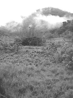
In general the secondary forest on old Yanomami gardens at Homoxi was heavily dominated by Cecropia sciadophylla, clearly visible from the air as an apparently continuous flat canopy.  These areas have been burned following initial felling but have not been subjected to the repeated burning cycles and soil erosion associated with the creation of pasture in Amazonia.  In addition they are relatively small areas which have never been any great distance from the forest seed bank. 


Figure 13: Old secondary forest (Yanomami garden) near Baiano Formiga

Some of these old secondary forests have now reached a considerable size, individuals of Cecropia reaching 25-30m with diameters of 40-50cm.  There are few other large tree species in the canopy with the exception of Croton palanostigma, Alchorneopsis floribunda, Inga spp. and Colubrina(?) sp.  However, the understorey is considerably more diverse with smaller trees, shrubs and herbs such as Bellucia grossularioides, Inga edulis, Maprounea guianensis, Elizabetha princeps, Bactris corosilla, Vismia spp., Faramea guianensis, Picramnea spruceana, Miconia nervosa, Psychotria poeppigiana, Piper spp., Costus spp. and Heliconia spp.  Woody vines include the common Pinzona coriacea and Bauhinia guianensis.

The Vismia forests at Homoxi tend to occur on areas that have been heavily disturbed by garimpeiro activity, including the edges of airstrips and the margins of the worked gravel areas.  The most common species is V. guianensis, which is usually strongly dominant.  The phenomena noted by Mesquita et al. (2001), i.e. the relatively low diversity and the preponderance of Vismia regeneration below the canopy, were clearly observable in these secondary forests.  They are generally lower (8-10m) and denser than the Cecropia forests, with more slender trees (10-15cm diameter).  Small Vismia saplings were commonly observed extending beyond the edge of these Vismia forests in an apparent attempt to colonise the surrounding areas.  However, the most distant of these had often been killed by fire or drought.
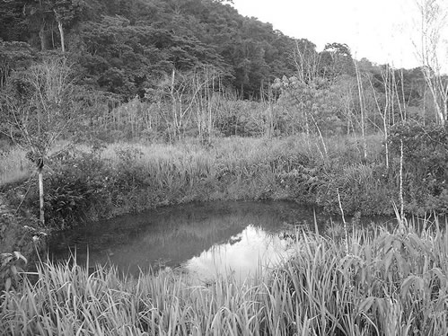
 

Figure 14: Edge of a lagoon near the Homoxi Post

Lagoons

Aquatic vegetation in the manmade lagoons at Homoxi was not surveyed in detail.  The levels of vegetation vary considerably, depending partly on the depth and the bottom substrate.[2]  Most lagoons are surrounded to one degree or another by Ludwigia spp: in particular L. leptocarpa.  Shallow lagoons or lagoons with shallows at their margins support areas of Pontederia sp. and, in their shallowest parts (which are probably dry in the dry season) patches of water-tolerant herbs and shrubs such as Begonia fischeri, Aciotis purpurascens, Siphanthera sp., Chelonanthus longistylus, Xanthosoma sp., Costus sp., Hibiscus furcellatus, Centropogon cornutus, Desmodium incanum, Kyllinga pumila, Pityrogramma calomelanos and Piper aduncum.
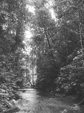
 Riverine vegetation

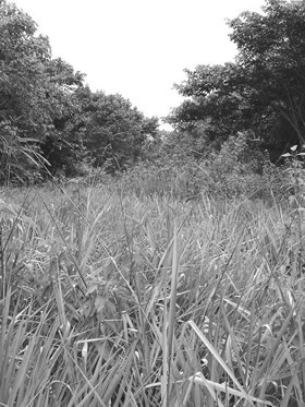
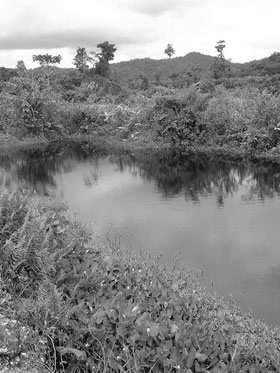
Given the extent of mining activities at Homoxi almost all of the riverine vegetation that was observed was to some extent secondary in nature.  In general the Mucajaí is now bordered by open areas covered by a dense tangle of  herbaceous or shrubby vegetation with vines.  In the places where a high gravel bank borders the river this vegetation is restricted to a narrow strip at its base, the top of the bank sometimes supporting a strip of shrubs or small trees before giving way to grass-covered gravels (see Figs 52 and 53).  In other places, however, there is a considerable area of flat land beside the river that is periodically flooded during the wet season and has accumulated silty soil.  In these areas there can be large expanses of this type of herbaceous tangle.

The floristic composition of this environment is not dissimilar from that of the edges of the lagoons.  Species encountered included Centropogon cornutus, Ludwigia spp., Hyptis cf obtusa, Hibiscus furcellatus, Mendoncia aspera, Palicourea crocea, Cestrum sp., Justicia secunda, Urera caracasana, Besleria sp., Pityrogramma calomelanos, Mucuna urens, Mikania micrantha, Xanthosoma sp., Solanum stramoniifolium, Piper aduncum and Uncaria tomentosa.

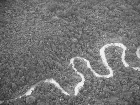
This type of herbaceous vegetation probably occurred in small areas beside the river prior to the mining activities, principally on the inside of bends (see Fig. 41).  However, the predominant riverine vegetation prior to disturbance would have been forest.  These pristine riverine forests, which were not observed directly, were said to have included several species of Inga (including I. edulis and I. acreana), Micrandra rossiana, Micropholis spp., Anacardium giganteum and Pseudolmedia spp.


Figure 15: Profile across gravel area downstream of the Homoxi Post

The profile spans the area between a small vegetated island in the Rio Mucajaí (Point 1) and the edge of the forest beside a man-made lagoon (Point 2).  Not to scale vertically.

A

Herbaceous tangle to 1m beside Rio Mucajaí, with Ludwigia leptocarpa, Centropogon cornutus, Hibiscus furcellatus, Hyptis cf obtusifolia, Mikania micrantha and occasional Pityrogramma calomelanos  ferns.

B

Shrubby vegetation to 2-3m with Piper aduncum, Miconia nervosa, Clidemia hirta, Jacaranda copaia, Palicourea crocea, Miconia tomentosa, Desmodium sp., Mucuna pruriens, Trema micrantha and Digitaria insularis.  Pityrogramma calomelanos abundant on the gravel bank.

C

Top of bank with Clibadium cf sylvestre, Clusia sp. and Piper aduncum.

D

Gravel area with sparse cover of Cladonia subradiata and Axonopus purpusii and occasional individuals of Emilia sonchifolia and Chamaecrista nictitans.  Patches of thin sandy soil (generally in depressions in the gravel) with Digitaria sp., Desmodium sp. and occasional Clibadium and Psidium guajava bushes. 

E

Edge of secondary forest with Uncaria tomentosa, Baccharis trinervis, Clidemia hirta, Cissus sicyoides, Conyza bonariensis, Andropogon angustatus, A. bicornis and Digitaria insularis,

F

Band of secondary forest to 8m with Ficus sp., Piper aduncum, Miconia nervosa, Vismia guianensis, Vismia japurensis, Uncaria tomentosa, Cissus erosa and Mucuna pruriens.

G

Tangled dense vegetation (mainly herbaceous) on damp ground with Cyathea sp., Costus sp., Uncaria tomentosa, Piper aduncum and Miconia nervosa.


Figure 16: Profile across gravel area upstream of the Homoxi Post

The profile spans the area between a small vegetated island in the Rio Mucajaí (Point 1) and the edge of the forest beside a manmade lagoon (Point 2). Not to scale vertically.

A

Island with secondary vegetation to 5m including Piper aduncum, Hieronyma laxiflora, Heliconia bihai, Machaerium sp., Mucuna pruriens, Cyathea sp. and Miconia cf macrotis.  River margin with Xanthosoma sp., Ludwigia octovavis, L. aff. foliobracteolata and Hyptis cf obtusifolia.

B

Tangle of shrubby vegetation to 3-4m including Piper aduncum, Securidaca sp., Pteridium arachnoideum (particularly on gravel bank), Cyathea sp., Mucuna pruriens, Costus sp., Desmodium adscendens and Panicum pilosum.  Hyptis cf obtusifolia and Centropogon cornutus growing on the river margin.

C

Low, mainly herbaceous vegetation (some small shrubs and saplings) on sandy soil with Psidium guajava, Clibadium cf sylvestre, Coussapoa asperifolia, Paspalum sp., Vismia guianensis, Cissus erosa, Stigmaphyllon sinuatum, Cecropia sp., Pteridium arachnoideum, Andropogon angustatus, Desmodium adscendens, Elephantopus mollis and Baccharis trinervis.  Some dead individuals of Piper and Vismia (killed by fire?)

D

Depression in gravels with very shallow sandy soil supporting Elephantopus mollis, Pityrogramma calomelanos, Pteridium arachnoideum, Mahurea exstipulata and Desmodium adscendens.

E

Gravel with very sparse low vegetation including Cladonia subradiata, Andropogon angustatus and occasional individuals of Emilia sonchifolia and Desmodium adscendens.  Occasional small Clibadium, Mahurea and Psidium shrubs.

F

Depression in gravels with Ficus paraensis, Piper aduncum, Clibadium cf sylvestre and Elephantopus mollis.

G

Depression with dense grasses including Paspalum sp., Andropogon angustatus and Rhynchelytrum repens.  Also Desmodium sp. and Emilia sonchifolia.

H

Lower gravel slopes dominated by Paspalum sp.

I

Top of mound dominated by shrubs to 3m dominated by Piper aduncum and Clibadium cf sylvestre.  Also Desmodium, Emilia sonchifolia and Elephantopus mollis.  Lower (damper) ground between I and H (some sandy soil) with ground layer of Cyperaceae, immature Chelonanthus longistylus and Paspalum cf amazonicum (also sparse shrubs).

J

Open area on damp sandy soil with Cyperaceae (including Cyperus surinamensis, C. luzulae and Scleria cf microcarpa), Lycopodium cernuum, Pityrogramma calomelanos, Chelonanthus longistylus, Clusia sp. and Desmodium sp.

K

Manmade lagoon with Xanthosoma sp., Hibiscus furcellatus, Ludwigia leptocarpa, Siphanthera sp. and Kyllinga pumila around the edge.  Some Pontederia sp. in the lagoon itself. 

L

Forest edge with Jacaranda copaia, Croton palanostigma, Cyathea sp., Machaerium sp., Miconia nervosa, Bauhinia sp. and Paullinia rugosa.

M

Forest with canopy approx. 25m and trees to 40cm diameter.  Species include Elizabetha princeps, Swartzia schomburgkii, Protium sp., Socratea exorrhiza, Ischnosiphon arouma, Psychotria poeppigiana, Geonoma sp.


Airstrips

Most of the airstrips in the Homoxi region support similar vegetation.  In general the central strip, whose soils are relatively compacted, is covered with a dense layer of Paspalum sp. interspersed with occasional shrubs and other herbaceous species.  Either side of the central strip is an area that would have been kept clear for the aeroplanes’ wings until the airstrip was closed.  This supports a dense secondary forest to a height of about 8m dominated by Vismia guianensis with additional species such as Croton palanostigma and Inga edulis.  The Vismia is gradually encroaching on the central strip from either side, and in some cases has virtually closed it.

Either side of the Vismia forest is generally a taller forest dominated by Cecropia sciadophylla.  In some cases this represents an area that may have been cleared when the airstrip was first constructed, but in most cases it is probably the result of previous Yanomami swidden clearings.[3]


Figure 17: The Baiano Formiga airstrip in 1990 showing the bomb-pitted runway and the abandoned buildings.

Several of the airstrips are clearly marked by the bomb-holes created by the Federal Police during Operação Selva Livre (1990) and subsequent attempts to close down the gold mines.  These holes, which can be as much as 1.5m deep and 4m across, have in some cases become partially filled with water.  In general the forest regeneration surrounding these holes is markedly more advanced than elsewhere on the airstrips, to the extent that many are surrounded by a distinct ring of trees.  This is presumably a consequence of the loose soil that was thrown up by the bombs.

Figure 18: Profile across an abandoned airstrip at Homoxi (Pista Pau Grosso)


A

Runway (compacted soils) dominated by Paspalum cf amazonicum, with patches of Desmodium sp. and patches of Baccharis trinervis.  Occasional saplings of Inga edulis and Vismia guianensis.  Other species include Sabicea villosa, Cissus erosa, Costus sp. and occasional shrubs of Piper aduncum and Solanum rugosum.

B

Secondary forest edge with Vismia guianensis, Inga edulis, Croton palanostigma, Laetia procera and Trema micrantha.  Renealmia alpinia and Costus sp. in the damper areas (where water drains from the runway).

C

Secondary forest approximately 8m tall dominated by dense Vismia trees (mainly V. guianensis).

D

Secondary forest approximately 20m high dominated by Cecropia sciadophylla.


The following additional observations were made at specific airstrips:

·         Chimarão: The central strip is densely covered in Paspalum cf amazonicum, with Desmodium sp. beneath it in some parts.  Other species present include Sabicea villosa, Bactris maraja (with wasps’ nests amongst its fromds) Psidium guajava, Heliconia sp. and Baccharis trinervis, with occasional Elephantopus mollis and Lycopodium cernuum.  The edge vegetation includes Lantana trifolia, Piper aduncum, Palicourea guianensis and Inga edulis.  Either side of the airstrip the secondary vegetation is dominated by Vismia guianensis (approx. 10m), which is clearly invading the strip.  Further back the forest is dominated by Cecropia sciadophylla to a height of 20m.

·         Baiano Formiga: The airstrip itself is mainly dominated by Paspalum cf amazonicum with Desmodium sp., although other species such as Psidium guajava occur.  The secondary forest on either side, which is visibly closing in on the strip, is dominated by Vismia spp. but also includes Croton palanostigma, Palicourea guianensis, Machaerium sp., Piper aduncum, Clidemia hirta, Mucuna pruriens and Miconia nervosa.  Bomb-holes are surrounded by trees to 10cm in diameter including Inga spp., Jacaranda copaia, Machaerium quinatum and Cyathea sp.  At the western end of the airstrip there is a large open area (with a single cashew tree) where the vegetation varies according to the substrate.  The more gravelly soils are dominated by Sauvegesia erecta with some Gramineae (including Panicum rudgei), whereas damper patches with more sandy substrates support Rhynchospora rugosa and Lycopodium cernuum.  There are also patches of Andropogon bicornis and Melinis minutifolia (introduced grasses) and of dead Vismia saplings to 1-2m.  Since there was no evidence of recent fire, these may have been killed by drought.

·         Macarrão: The vegetation is similar to that at Baiano Formiga.  Central strip dominated by Paspalum cf amazonicum.  Occasional shrubs such as Lantana trifolia and Piper aduncum.  Secondary forest either side dominated by Vismia spp. with Croton palanostigma, Inga edulis, Mucuna pruriens, Desmodium sp, Palicourea crocea and Trema micrantha at the edge.

·         Julio de Blefe: This airstrip has been almost completely closed in by secondary forest.  There are few trees >10cm diameter, apart from a few around the bomb-holes.  Vismia guianensis is a common species in the regeneration.  Patches that have not closed completely are mainly covered in a ground layer of Panicum pilosum (and in places Nephrolepis sp.) with shrubs and small trees such as Bactris maraja, Leandra sanguinea, Inga edulis, Psychotria poeppigiana, Psychotria cf brachybotrya, Stenoselon heterophyllus, Heliconia spp. and Costus spp. The secondary forest either side of the strip, which includes Alchorneopsis floribunda, Colubrina sp., Jacaranda copaia, Bellucia grossularioides and Cecropia sciadophylla (mainly dead), contains trees to 25m with diameter up to 25cm. There is a mango tree there that was said to have been planted by the Federal Police.


Figure 19: Macarrão airstrip (left) and crashed DC3 beside the Homoxi airstrip (above)


The effects of fire

The relationship between the Yanomami, fire and altered environments has been discussed in some detail by Huber et al. (1984) in relation to the savannas and other herbaceous formations of the Sierra Parima in Venezuela.  Although the grass-dominated savannas are thought to be ancient formations of natural origin, the fern-dominated units are clearly the result of repeated burning by Yanomami communities.

There was considerable evidence of past burning in many of the secondary habitats in the Homoxi region, particularly on the open gravel areas.  These are covered by dry grasses and other herbaceous material, and are easily burned at the end of the dry season, whether deliberately or accidentally.  Fire is an easy way to keep trails through herbaceous vegetation open (such as those that follow the gravels along the Mucajaí), and deliberate burning for this purpose has been reported elsewhere among the Yanomami (Huber et al., 1984).  One such burned area on the gravels along the Mucajaí was said to have been deliberately burned in order to drive out paca (Acouti paca) during a hunt.  This area had been recolonised by a dense growth of Pteridium arachnoideum.


Figure 20: Burned area with Pteridium


In several of the open areas at Homoxi the grasses were found to be in the process of regenerating after such a fire, and many of the shrubs and saplings of pioneer species such as Vismia guianensis and Piper aduncum were dead (presumably as a result of heat shock).  Substantial patches of small dead trees (mainly Vismia) were observed in a number of places, however, and although some of these are probably the result of burning, others may be a consequence of periods of drought.[4]

On the whole, apart from the burning of deliberately felled forest for swidden cultivation, it is only the herbaceous and scrub formations that are significantly affected by fire.  However, during particularly dry periods, it is occasionally possible for forest to be set alight. The most extensively burned area was observed on a hill to the east of the Homoxi Post, where the secondary forest was said to have caught alight during a particularly harsh dry season when a neighbouring patch was burned for swidden cultivation.  This is now covered in a dense layer of Pteridium arachnoideum, with very few other species amongst it. 

Another area of secondary forest that had been accidentally burned by the Yanomami (while destroying a wasp nest) was observed close to the Pau Grosso airstrip.  The forest, which was dominated by large individuals of Cecropia sciadophylla to a height of 25m, had been thinned substantially by the fire although not completely destroyed.  Huber et al. (1984) report similar thinning of forest by fire in the Venezuelan Sierra Parima, where the more seasonal climate can leave the forest highly combustible at the end of the dry season.

Differences in the natural vegetation between Homoxi and Yaritha

The Yanomami distinguish the highlands (horepë a) from the lowlands (yari a) partly on the basis of tree species distribution.  The presence of Micrandra rossiana (momohi) and Micropholis sp. (nai hi), for example, and the absence of species such as the Brazil nut (Bertholletia excelsa) are regarded as indicators of highland forests.  The main Homoxi region falls into the horepë a category whilst Yaritha, which lies on the far side of the Orinoco/Amazon watershed,[5] is just within the lowland forests.  This is indicated both by the absence of momohi and nai hi and by the presence of a number of lowland species which are not found in the uplands forests of Homoxi.  Bertholletia excelsa, however, is absent, as is Maximiliana maripa (a common lowland palm species).  Other lowland species such as Couma macrocarpa and Genipa americana, which are rare around Homoxi, were said to be found in abundance at Yaritha.

Table 1: Some tree species absent from Homoxi but present at Yaritha

Euterpe precatoria

Palmae

maimasi

Hymenaea parvifolia

Leguminosae

arõ kohi

Jessenia bataua

Palmae

koanarima si

Lonchocarpus sp.

Leguminosae

kuna ãthe

Theobroma bicolor

Sterculiaceae

himoro amohi

Theobroma cacao

Sterculiaceae

prorounahi

Theobroma subincanum

Sterculiaceae

waiporounahi

Unknown.

Unknown.

makinahi

Alien plant species

Without prior data on the vegetation of the Homoxi region it is impossible to give an accurate account of the nature and extent of species introduction.  Many of the weedy species found in the regenerating areas may have been present in natural and man-made forest clearings, riverine vegetation and edge zones prior to the arrival of the garimpeiros.  Nevertheless several species have clearly been introduced, either accidentally or deliberately, during or since that period.  

The most obvious of the deliberately introduced species are the fruit trees, in particularly guava (Psidium guajava) and inga (Inga edulis).  Guava is one of the few species of shrubs or small trees that have managed to colonise the gravel areas.  Hibiscus sabdariffa (vinagreira) was found growing abundantly one one patch of gravel downstream of Homoxi, but nowhere else.  This herb has edible acid-tasting leaves and is commonly cultivated in the State of Maranhão (from whence many of the garimpeiros came).  It was almost certainly introduced deliberately.  Sesamum indicum (sesame), on the other hand, which was common on the gravel areas between the Post and the river (but not observed elsewhere), may well have been introduced accidentally (the seeds may have been brought in as food).


[1] In some areas this lichen is the only plant species that has been able to colonise the gravels.  It seems to be able to lock up a fine layer of organic matter and sand in its roots, and it may therefore be contributing towards the early stages of soil regeneration.

[2]  It may also depend on the level of water pollution.

[3] The airstrips were mainly constructed close to the rivers (i.e. close to the gold deposits), which are generally relatively fertile and have long been favoured as swidden sites by the Yanomami communities in the region.

[4] One such drought during the El Niño event of 1998 resulted in uncontrolled fires across the State of Roraima.

[5] The limit of the uplands (and of the distribution of momohi and nai hi) are apparently midway down the course of the Wiramapi u.  This is itself a tributary of the Hayathë u, which is a tributary of the Ruapë u, which is a tributary of the Hara u (the Orinoco). Yaritha lies downstream of the Hayathë u.